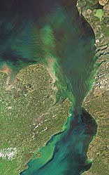
Site 1.
English Channel
Product User Guide Version 2.2

|
Products
V2 On-Demand Processing no longer available
After more than seven years of free coastcolour processing service, we decided to close the service now due to outdated input products and software versions.
The service will no longer be available to the public by February 2022.
If you are interested in any of our water quality services, please visit our website
or contact us directly under info@brockmann-consult.de
Version 2 processing did include:
- Access to the complete global MERIS Full and Reduced Resolution data archive, covering the time range from 17. May 2002 until 08. April 2012.
- MERIS L1b FRS as well as RR products with harmonized calibration across the full mission and consistent with the 3rd MERIS Reduced Resolution (RR) reprocessing are used as input data
- L1P processing with improved geolocation, additional radiometric improvements (coherent noise equalisation, Smile correction) and pixel classification (cloud screening, improved land-sea mask, other pixel attributes). Performing adjacency correction is optionally possible.
- L2R processing applying a neural network based atmospheric correction, which is applicable for a large range of water type, from clear to extreme scattering waters.
- L2W processing providing water properties, such as inherent optical properties, chlorophyll and suspended matter concentration, diffuse attenuation coefficient Kd and Secchi Disk Depth. In V2 processing an improved algorithm is applied for the chlorophyll-a retrieval using a blending of clear water OC4 algorithm and a neural network for turbid waters.
The on-demand processing replaced the V1 archive of the 27 pre-defined scenes. For convenience, the access to the V1 data archive remained online until end of June 2014.
The main advantages and features of the Calvalus On-Demand Processing System were:
- No need to download large pre-defined product sets. They were tailored to your region of interest.
- The system enabled you to generate specific product level data sets (L1P, or L2R or L2W) according to your needs.
- Specification of your specific time periods, regions, and processing parameters.
- Choice between Full or Reduced Resolution input data sets.
- Building of your own processing chain by using the outputs of one processing step as the inputs for a subsequent step.
The selected data were processed automatically on the Calvalus cluster located at Brockmann Consult. The results were made available for download via HTTP and ftp. Registered CoastColour users could find the data in their personal coastcolour ftp account.
Read here an introduction to the system
CoastColour V2 Processors available in BEAM
With the BEAM Release 5, the CoastColour V2 processors are available as modules. Read here how to get them.
Product Description
The Level 1P product is a refined top of atmosphere radiance product compared with the standard Level 1b product. It provides improved geolocation, equalisation to reduce coherent noise, smile correction, pixel characterization information (cloud, snow, etc.), a precise coastline and a reformatting into NetCDF following Climate Forecast (CF) conventions. NetCDF format is the CoastColour default; other output formats are GeoTIFF and BEAM-DIMAP.
The Level L2R product is the result of the atmospheric correction. It contains water leaving reflectance, normalised water leaving reflectance and different information about atmospheric properties. It also contains an ortho-corrected geo-coding and different flags characterizing pixels.
The L2W product provides information about water properties such as IOPs, concentrations and other variables. It also contains an ortho-corrected geo-coding and different flags characterizing pixels.
The following table gives an overview of the product structure. A dataset is physically represented by one single NetCDF product file.
| Dataset |
Band Name |
Contents |
L1P |
radiance_i |
Pre-processed MERIS TOA radiances. |
lat, lon, altitude |
Ortho-corrected geo-coding. |
l1_flags |
Copy of input Level 1 flags |
l1p_flags |
Additional pixel classification information:
- land, coastline from improved geocoding and SRTM land-water map
- cloud flags
- snow/ice flag
- water/land mixed pixel
- glint risk |
L2R |
reflec, norm_reflec atm_tau_550, ang_443_865 |
Contains water leaving reflectances, normalised water leaving reflectances, aerosol optical depth and angstrom exponent. Optionally the user can add other variables (using the Calvalus On-Demand processing or the BEAM CoastColour processor) |
lat, lon, altitude |
Ortho-corrected geo-coding. |
l1_flags, l1p_flags |
Copy of flags provided in the L1P product |
l2r_flags |
Flags providing additional information on the atmospheric processing |
L2W |
iop_a_total, iop_a_ys_443, iop_a_pig_443, iop_bb_spm_443, iop_a_det_443, iop_b_tsm_443, iop_b_whit_443, iop_a_dg_443, iop_quality |
Inherent optical water properties calculated by a neural network |
qaa_iop_a_total_443, qaa_iop_a_ys_443, qaa_iop_a_pig_443, qaa_iop_bb_spm_443 |
Inherent optical water properties calculated by the QAA algorithm |
conc_tsm, conc_chl_nn, conc_chl_oc4, conc_chl_merged, conc_chl_weight |
Concentrations of water constituents. The chlorophyll concentration is calculated twice for each pixel: with a neural network which performs best for high turbid waters (conc_chl_nn), and the OC4 algorithm (conc_chl_oc4). A blending between the two variables is done based on the tsm concentration. The weight provides the relative portion of the chl_nn. |
kd, z90_max, turbidity
|
Other water properties (spectral Kd and Kd_min, Z90_max, turbidity_index) |
- Not in CoastColour on demand processing but available offline as BEAM processor -
|
Fluorescence line height, Maximum chlorophyll index |
kd, z90_max, turbidity
|
Other water properties (spectral Kd and Kd_min, Z90_max, turbidity_index) |
lat, lon, altitude |
Ortho-corrected geo-coding |
l1_flags, l1p_flags
|
Copy of flags provided in the L1P product |
l2r_flags |
Copy of flags provided in the L2R product |
l2w_flags
|
Water constituents and IOPs retrieval quality flags |


|