Contents
Site 7.
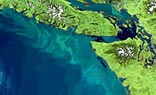
Oregon and Washington
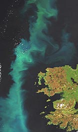
Site 1.
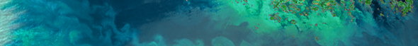
North Atlantic

|
Project Description
The importance of the coastal zone for economic activities, and the anthropogenic stresses on the ecosystem, have been described and discussed widely throughout the past 20 years.
Responding to this, ESA designed the MERIS instrument specifically to provide measurements most suitable for coastal zone management and research. In space for 8 years, MERIS has delivered a unique global dataset of coastal zones at 300m spatial resolution, which deserves dedicated processing with internationally agreed algorithms, and provision of products targeted to specific user needs, properly documented and easily accessible.
Beyond this immediate goal this dataset will become an important contribution to further understanding of the coastal zone in climate change, its importance in the global carbon cycle, the generation of biogenically-active gases and its sensitivity and response to changes in temperature, sea level and water mass distribution.
CoastColour will work towards these objectives by developing, demonstrating, validating and intercomparing different Case 2 algorithms over a global range of coastal water types, identifying best practices, and promoting discussion of the results in an open, public form.
Main Results
- Internationally discussed protocols for Case2 waters processing including algorithm performance assessment;
- A global set of MERIS FR data of coastal zones at a regional scale, processed with best possible algorithms for Level 1, with best possible regional algorithms for water leaving reflectances and IOPs, and demonstrating processing of regional higher level specific products; all products including per pixel error/uncertainty estimates;
- An international comparison of Case 2 algorithms, involving all relevant stakeholders and open to the scientific community;
- Actively demonstrating and promoting MERIS capabilities for Case 2 water processing to the international ocean colour radiometry community, and increase of usage of MERIS within and outside Europe;
- Preparation of the future exploitation of MERIS and Sentinel 3 products for operational Case 2 product applications and for climate change studies.
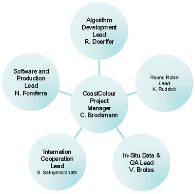
Scientific/Industrial Team
A highly skilled international team has been constituted under the leadership of Dr. Carsten Brockmann from Brockmann Consult (Germany):
- Dr. Shubha Sathyendranath and Prof Trevor Platt FRS from the Plymouth Marine Laboratory (PML, UK) embed the CoastColour project into key international working groups, such as the IOCCG, ChloroGIN, GEO, the LOICZ project office and others; Steve Groom and his team of the Remote Sensing Group at PML contribute to the algorithm development, in-situ data and validation;
- Dr. Roland Doerffer and his colleagues from the Institute of Coastal Research of the Helmholtz Center Geesthacht (Germany) lead the scientific work associated with the algorithm development and regional adaptation;
- Dr. Kevin Ruddick, leader of the remote sensing group of the Management Unit of the North Sea Mathematical Models (MUMM, Belgium), is responsible for the Round Robin intercomparison of Case2 algorithms and the validation;
- Prof. Richard Santer from the University of the Littoral Opal Coast (LISE, France) is in charge of the atmospheric characterisation and regionalisation;
- Prof. Vanda Brotas from the Centre of Oceanography of the University Lisbon (CO, Portugal) is responsible for the in-situ data validation and management;
- Norman Fomferra and Uwe Krämer together with their teams at Brockmann Consult take care of algorithm implementation, verification and data processing.
  Group of Consultants
This core team is supported by a group of consultants who provide specific expertise. This injection of know-how is one key to success for a project that shall provide, at a global scale, regional products with best adapted regional algorithms. The group of consultants comprises Prof. Yu-Hwan Ahn (KORDI, East Asian Waters processing), Dr. Jim Gower (DFO, Fluorescence Line Height), Dr. Mark Dowell (JRC, classification of marine waters), Dr. Stewart Bernard (CSIR, Regional IOPs and HABs), Dr. Zhongping Lee (U. Mississippi, Analytical Case2 Algorithm), Dr. Bryan Franz (NASA, Ocean Colour Biology from SeaWiFS and MODIS) and Dr. Thomas Schroeder/Dr. Arnold Dekker (CSIRO, inversion algorithms and regional IOPs).
Science Team
Finally the work of the Brockmann Consult team will be supervised and guided by the Science Team. This team will act as a critical supporter, not being funded and hence an independent constructive advocate of the science and user community, with a minority involvement by members of the consortium. The Science Team comprises Mark Dowell (JRC), Gene Feldmann (NASA), Paul DiGiacomo (NOAA), Jürgen Fischer (FUB), Hubert Loisel (Lille), Kai Soerensen (NIVA), Prakesh Chauhan (ISRO), Trevor Platt (PML) and Steef Peters (IVM).
Team organisation
International cooperation
Case2 waters are of high interest to the international user community as expressed by the impressive number of participants of the CoastColour user consultation meeting and subsequently the commitment the users gave by proposing their sites to ESA.
CoastColour will keep close contact with the users and international bodies through the user consultation workshops, direct consultation of users for in-situ data and by putting CoastColour on the agenda of the key organisations including IOCCG, GEO, ChloroGIN, POGO and SAFARI.
Another import channel for outreach will be LOICZ. Major findings of this project will be disseminated via LOICZ reports and newsletter. These measures will ensure a continuous exchange of information in both directions: requirements and feedback from users to the project, and up-to-date information from the project to the users and the international ocean colour and coastal zone community.
Work Programme
At the high level the work programme is organised around 5 main lines of technical activities:
- Activity 1: Algorithm definition and development
Through discussion with the users, within the team and with the science team, all user requirements and algorithm requirements will be reviewed with the goal to identify in detail how the final CoastColour (CC) algorithms will look like and which data are required to calibrate and validate them. Due to the long experience of members of the team and the consultant group in developing algorithms for remote sensing of optically complex waters, a basic suite of dedicated coastal water algorithms is already available for different types of coastal waters including specialized atmospheric correction procedures. ATBDs will be developed for the selected algorithms, including algorithm validation. The algorithms will be implemented as BEAM processors. These will be applied first to the L1P processing (top of atmosphere reflectances, corrected for smile, attached precise geo-location from AMORGOS and attached cloud screening information and other quality flag information) and next to the L2R processing (atmospheric correction including adjacency effect correction, glint, bottom reflection and normalisation), then AOI specific water processing: IOPs, concentrations and higher level products.
- Activity 2: Production
The MERCI software will be upgraded in order to ingest, quality control and organise the MERIS FRS and complementing RR products. A link to the in-situ database will be implemented. On this database a processing system will operate that performs the L1P and L2 processing, based on both the BEAM processing technology and the standard ESA processing using the public megs processors.
- Activity 3: Validation
The validation starts with a review of existing protocols and the release of a CoastColour Protocol, in agreement with the international community and specifically compliant with the QA4EO guidelines. According to this protocol we perform quality control on the incoming in-situ data. Those will be compiled in an in-situ database. The database will be linked with the CoastColour MERCI containing the MERIS data and linked it with the CEOS CalValPortal. Supporting the MERIS match-up database MERMAID and the NASA SeaBAS data base is envisaged. The validation of the generated products includes match-up analysis, statistical evaluation and Level 3 analysis.
- Activity 4: Round Robin for selection of final water processing algorithms
The Round Robin intercomparison of Case2 algorithm will involve the international user community on a voluntary basis. Participation will be stimulated at the beginning of the project by a range of publicity activities including contributions to IOCCG and NASA e-newsletters, the IOCCG web site and major international conferences such as: SAFARI (India, Feb 2010), Oceans from Space (Italy, Apr 2010), ESA Living Planet (Norway, June 2010) and/or OceanOptics (Alaska, Sep 2010). A protocol for the performance of the Round Robin will be established. We will base this strongly on the protocol used for IOCCG Case1 algorithm intercomparison (IOCCG Report 5). A dataset comprised of L1P as well as L2R water leaving reflectances will be distributed to the users which will run their water retrieval algorithms. The evaluation of the results, including the user algorithm, the standard L2 products and the CoastColour processing, will be done carefully and with support from the science team. The CoastColour Case2 Algorithm Round Robin will be proposed for publication as an IOCCG Report, and key findings will be submitted for publication in a peer reviewed journal.
- Activity 5: Communication and interaction with international groups and users.
Case2 waters are of high interest to the international user community as expressed by the impressive number of participants of the CoastColour user consultation meeting and subsequently the commitment the users gave by proposing their sites to ESA. We will keep close contact with the users and international bodies through the user consultation workshops, direct consultation of users for in-situ data and by putting CoastColour on the agenda of the key organisations including IOCCG, GEO, ChloroGIN, POGO and SAFARI. Another import channel for outreach will be LOICZ. Major findings of this CC project will be disseminated via LOICZ reports and newsletter. Identification of a CoastColour partner for liaison with each test site will optimise involvement. These measures will ensure a continuous exchange of information in both directions: requirements and feedback from users to the project, and up-to-date information from the project to the users. In addition to the personal contacts described above, this will be supported through newsletters and the Webportal which will be a distributed system with contributions from all partners, online access to EO and in-situ data.
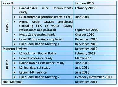
Project Schedule
Acknowledgement
CoastColour is grateful for the intensive support by ACRI-ST, France, concerning the calibration and AMORGOS geocorrection of MERIS. We also thank the CoastColour users for the contribution of in situ data for the specific sites.
Our thanks go to
|